P.
L. Narula, Former Dy Director General
Geological
Survey of India, Faridabad, India
and
S.
K. Chaubey, Department of Civil Engineering,
Indian
Institute of Technology Kanpur, India
Kutch
region of Gujarat state of India was struck by a devastating earthquake
of magnitude 7.7 (Mw) at 08 hrs 46 min (IST) on the 26th
Jan 2001. The earthquake has taken huge toll of life and property
in the meizoseismal area as well as in cities of Ahmedabad, Bhavnagar
and Surat located at large distances from the epicenter. This provided
a challenge for constraining the isoseismals as well as intensity
attenuation and accentuation patterns.
A-
Isoseismal Patterns
The reconnaissance surveys were conducted
between the 3rd and 10th Feb 2001 which included
an air reconnaissance followed by long traverses to assess the general
damage patterns, terrain changes brought about and to look for ground
rupture. The preliminary isoseismals have been constrained utilizing
the MSK scale (Medvedev-Sponheuer-Karnik).
During the preliminary surveys of selected
RC buildings in Ahmedabad it was seen that many RC structures have
suffered high grade of damage (Grade 5 as defined in MSK scale). About
69 such buildings collapsed in Ahmedabad while no major damages were
caused to most of the B-type structures as well as adobe constructions
in the outskirts of the city. Such inconsistent damage patterns would
make the job of isoseismal surveys a difficult proposition. Keeping
this in mind the MSK scale in conjunction with the vulnerability classes
suggested in the European Macroseismic scale (EME-92), which was adopted
by the XXIII ESC General Assembly, 1992, held in Prague has been used.
This has helped in removing the constraints of inconsistent damage
patterns in different types of structures.
The reconnaissance surveys have indicated
that intensity X has been reached in an elliptical tract of about
2100 sq.km, which is characterized by complete destruction of adobe,
brick and stone masonry buildings and many RCC buildings have suffered
grade 4 to grade 5 damages (Photo Plates 1 and 2); wide ground fissures
and collapse of low height road embankments. This epicentral tract
includes villages of Jawaharnagar, Dudai, Adoi, Chobari, Manfara,
and Rapar. The long axis of this epicentral tract is aligned in ENE-WSW
to E-W direction with maximum damage concentrated near its northern
and southern boundaries.
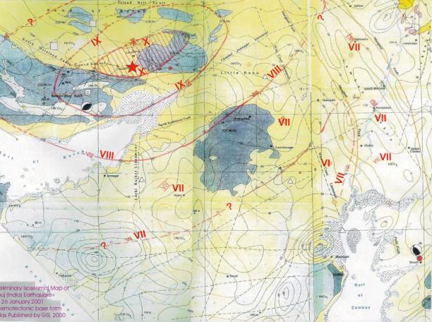
During the reconnaitory surveys only
the southern boundaries of the isoseismal IX, VIII and part of VII
could be constrained and the eastern, western and northern boundaries
are tentative because complete area could not be traversed during
the time frame of investigation. These will have to be verified by
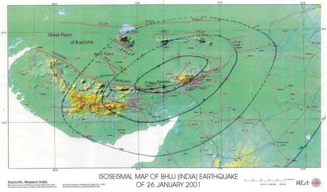
more detailed surveys. The preliminary isoseismal map is appended
as Fig.1a and 1b.
The distribution of intensity VII is
quite interesting and has deviated from the general E-W elongation,
consistent with higher isoseismals, to almost north-south pattern
along the area occupied by deep seated Quaternary and Cenozoic cover
sediments along the Cambay Graben. The accentuation of the motions
because of these thick cover have resulted in modification of boundaries
of isoseist VII. In all the isoseists there were isolated areas of
lower or higher intensities depending upon the geotechnical characteristics
of the ground. One such conspicuous area is the township of Limbdi
located within isoseist VII which shows damages similar to those of
isoseist VIII.
B-
Terrain Changes
Widespread liquefaction has been recorded
in the Rann of Kutch, the Little Rann of Kutch as well as the coastal
areas of the Gulf in the vicinity of Ghandidam, Kandla, and between
Malya and Samakhiali. The liquefaction has been recorded profusely
in isoseist VIII to X. The liquefaction signature in the epicentral
tract particularly dry stream beds is conspicuous. The liquefaction
has manifested along long fissures and at many places it is vent type
(Photo Plate 3 and 4). This phenomenon needs detailed studies and
may be responsible for failure of some embankments in the meizooseismal
area. In the coastal areas areas evidence of lateral spreading has
also been recorded. Because of the low height hills in the area, widespread
landslides as well as dislodgment are not prevalent. However, a few
significant landslides on the left bank of Pur nadi (stream), a few
dislodgements around Nadapa and shaving of steep rock bluffs have
been recorded in isoseists IX and X.
Wide spread ground fissures have been
recorded, most significant of which are the step like en-echelon fissures
in the Amarsar-Desalpur sector, near Kharoi and near the bridge on
Pur nadi about 10 km north of Bhuj town. The ones near this location
are significant as these are in continuation of a rock bluff (fault
scarp ?) and do not show evidence of these being related to liquefaction.
These ground fissures need further explorations, particularly in the
western as well as eastern extensions where rock outcrops are seen.
C-
Fault Rupture
No direct evidence of fault rupture
were recorded in the area but the ones near the Pur nadi bridge are
the most significant ones (Photo Plate 5 and 6), as these are located
in the near vicinity of the Kutch mainland Fault zone which displays
a number of steep fault scarps with slopes towards north and having
been displaced by transverse features. It is possible that the signatures
seen, of tensional (extensional) regime, are similar to the ones preserved
as fault scarps. The areas in the vicinity of Lodai and Dharang villages
near which the extended portion of these fissures would continue record
extensive fissuring, and it needs further palaeoseismological investigations.

Photo Plate1: Devastated
village - Jawaharnagar which was relocated at this site after the
Anjar earthquake of 1956. The same has collapsed as no aseismic design
interventions were made during the rehabilitation and reconstruction
of this village.

Photo Plate2: Completely
destroyed 660 KVA Power Station 1 km short of Adoi in the epicentral
tract.

Photo Plate3: Vent type
ejection as result of liquefaction, 14 km short of Bherandiala village
on Bhuj Khawda road.

Photo Plate4: Ground
fissures along with liquefaction in the Rann of Kutch –14km short
of Bherandiala village.

Photo Plate5: Bridge
on Rudramata Dam Reservoir – Pur Nadi, conspicuous straight east west
rock bluff on the right bank of the river.

Photo Plate6: Ground fissures
on the right bank of Pur Nadi near the bridge on Bhuj Khawada road.

Figure 1a: Isoseismal
map of Bhuj (India) earthquake of 26 January 2001. (Click on the picture
to view a larger image.)

Figure 1b: Preliminary
isoseismal map of Bhuj (India) earthquake of 26 January 2001. Seismotectonic
base from Atlas published by GSI 2000. (Click on the picture to view
a larger image.)