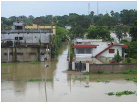
Waterlogging
Waterlogging can be described as stagnation of water on top of the soil surface and/or the presence of a high water table inside the soil. Waterlogging of the soil or deeper submergence occur when water enters soil faster than it can drain away under gravity.
Waterlogging and wetlands are natural processes and landforms in flood basins and coastal plains and are often termed as ‘kidneys” of earth due to their ecological functions. Research on waterlogging has revealed that topography plays an important role in the horizontal movement of water across the landscape, with water tending to collect in the lower, flatter areas — which will normally be subject to waterlogging for longer periods than higher ground. The vertical movement of the water through the soil profile is largely controlled by soil type and structure. Generally the higher the clay content of the soil, the slower the water will move through it and the longer it will remain wet. Additionally any impermeable layers in the subsoil such as natural clay or rock layers or a compacted layer caused by ploughing or vehicular traffic will also further impede drainage – resulting in a perched water table which causes the soil above to remain saturated.
Waterlogging not just makes the areas inaccessible and unusable for agriculture and living, they can damage the soil and ecosystem permanently and the recovery of such damaged ecosystems can be much more expensive and time-consuming. In recent years, unplanned development and urbanization have disturbed the equilibrium, and the extent of waterlogging has increased manifold due to drainage congestion and repeated flooding.
 |
 |