Intranet | Webmail | Forms | IITK Facility
Welcome Message
About
|
Motivation
The NCG was initially conceived on account of limited education in Geodesy at the national level. Although courses on Surveying and Mapping, Geoinformatics, Remote Sensing/ GIS, etc. are being taught at a few universities, none delve into the fundamentals and advanced concepts in Geodesy. Further, national expertise in areas such as Geodesy and SAR interferometry, is rather limited. Thus, there is a need for the development and training of human resources in the aligned areas.
Vision
To act as the hub of excellence in teaching and research in Geodesy at the national and international level by way of preparing well-trained human resources at post-graduate level, quality publications in reputed journals and through collaborative research with international institutes/institutions to contribute in the infrastructure development of the country. |
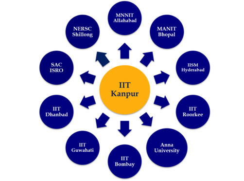
The proposed structure of NCG with IIT Kanpur as the central hub and other institutes as local centers.
|
||||||||||||||||||||||
|
Objectives Supported by the Department of Science and Technology, Ministry of Science and Technology, the primary objective of the NCG is to nucleate and strengthen activities in the area of Geodesy education, capacity building and academic research and development by:
|
Mandate
|
Featured Faculty
Latest News & Announcements
Recent Publications
Featured Alumni
|
Inauguration function of NCG
The inauguration ceremony for the NCG is organized on 6th September 4-6:00 PM, at the IITK Outreach Auditorium. The function will be followed by a visit to the poster session held by the Geoinformatics group to demonstrate the research conducted by the students. |
DIIT
|
Eligibility Requirements for the DIIT Program The eligibility for the DIIT Program is the same as that for our M.Tech/M.S. (Research) Programme, which includes the following.
For the DIIT program, the GATE requirement may be waived. However, preference will be given to working professionals in Government department/institutions, Industry, Faculty members in Academic Institutions involved in teaching and R&D in Geoinformatics. The DIIT program covers a minimum of 72 credits comprising coursework in the first and second semesters (36 x 2) and research work (18) though summer term projects. The coursework comprises compulsory and elective courses into three specializations, namely, Geodesy, Navigation and Mapping, and Remote Sensing/GIS.
|
|
Autumn School on Physical Geodesy and Its Applications
|
Ph.D.
|
Eligibility Requirements for Ph.D Programme The applicant must have a master’s degree in engineering with marks/CPI not below 65% marks (or CPI of 6.5 on a 10-point scale) or the minimum pass marks (or CPI) whichever is greater. Candidates belonging to the Scheduled Castes/Scheduled Tribes who have a master’s degree in engineering are eligible to apply irrespective of the marks/CPI. Candidates with a bachelor’s degree in engineering with marks/CPI not below 75% marks (or CPI of 7.5 on a 10-point scale), or a master’s degree in science or an allied area, satisfying each of the following criteria may be considered for admission into the Ph.D. programme:
Prospective candidates are encouraged to visit here for more details on the eligibility. |


